
Well trodden paths
2 posters
Page 1 of 1

Well trodden paths
![]() Jase_MK 2013-03-06, 04:49
Jase_MK 2013-03-06, 04:49
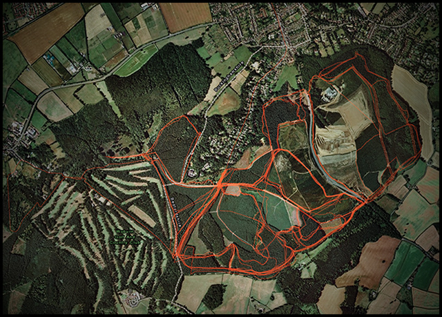
Was just sorting through some files on my PC and came across a folder with loads of GPS logged cyclone rides, collected over the last couple of years. As my job involves a lot of map making, I thought I'd plot them on top of each other and make a pretty little map of the well trodden paths round Aspley Woods...
Overlaid on a satellite image background, it's interesting enough...
... but if you take away the satellite imagery and plot on a plain background, you get a real picture of some of the trails we hammer quite a lot versus some of the less trodden paths. Something to think about, in terms of trail erosion and sustainability - certainly inspires me to try and vary our route choice as much as possible, not just to keep things interesting but also to balance out the impact we have on the trails. It also looks quite cool, in an abstract kind of way.
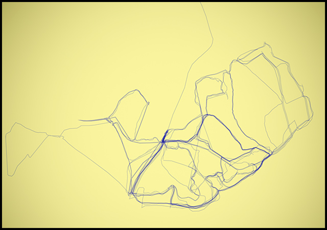
Sadly there's only about 10-15 rides worth of data there. If I had a good 100 rides or so worth of data, it'd make for a very cool little map.
Anyway, just thought some of you might find it interesting.
Overlaid on a satellite image background, it's interesting enough...
... but if you take away the satellite imagery and plot on a plain background, you get a real picture of some of the trails we hammer quite a lot versus some of the less trodden paths. Something to think about, in terms of trail erosion and sustainability - certainly inspires me to try and vary our route choice as much as possible, not just to keep things interesting but also to balance out the impact we have on the trails. It also looks quite cool, in an abstract kind of way.
Sadly there's only about 10-15 rides worth of data there. If I had a good 100 rides or so worth of data, it'd make for a very cool little map.
Anyway, just thought some of you might find it interesting.

Jase_MK- XT

- Number of posts : 136
Age : 46
Bike : FSR XC/Summer Season/Inbred SS
Registration date : 2008-04-22
Re: Well trodden paths
![]() Tom 2013-03-09, 16:36
Tom 2013-03-09, 16:36
Nice one Jase...
I have around 60 Cyclone sunday rides, so might try and do something similar. What tool did you use for this?
Tom

Tom- XT
- Number of posts : 140
Age : 40
Bike : Trek Remedy 9, Trek Madone 4.5
Registration date : 2006-10-29
Re: Well trodden paths
![]() Jase_MK 2013-03-11, 04:07
Jase_MK 2013-03-11, 04:07
Cheers Tom.
Used a combination of tools. I think the full process was:
GPSBabel to merge all GPX files into one.
DNRGPS to convert the big GPX file to an ESRI shapefile.
ArcGIS to plot the shapefile, then export to .AI
Adobe Illustrator to makes the track semi transparent, in order to show the build-up of multiple tracks.
Sounds like a faff, but it's all software I use for work
Jase_MK- XT
- Number of posts : 136
Age : 46
Bike : FSR XC/Summer Season/Inbred SS
Registration date : 2008-04-22
Page 1 of 1
Permissions in this forum:
You cannot reply to topics in this forum|
|
|